Store nearby ROMBAT
Romania
Store nearby ROMBAT
ROMBAT
Șoseaua Sibiului 55, Mediaș Rumänien
contacts phone
:
+40
Latitude:
46.1500065
, Longitude:
24.3294159
read more
nearest Store
7 m
Fortuna
Șoseaua Sibiului 55, Mediaș
Store
read more
108 m
Loteria Romana
Strada Calafat 10, Mediaș
Store
read more
288 m
ZebraPay
Str Blajului Bloc 68, jud. Sibiu, Sibiu
Store
read more
315 m
Ambient - Mediaș - Depozit
Șoseaua Sibiului 55, Mediaș
Store
read more
383 m
Ambient - Mediaș - Retail
Strada Iacob Pisso Str. Iacob Pisso nr .6, Mediaș
Store
read more
456 m
Stanleybet
Str. Ilarie Chendi, nr.2, Mediaș
Store
read more
476 m
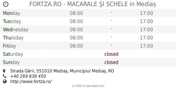
FORTZA.RO - MACARALE ŞI SCHELE
Strada Gării, Mediaș
Store
read more
521 m
Dealer Vodafone - Sayfone
Sos.Sibiului FN, Mediaș
Store
read more
576 m
Cofetaria Raema
Șoseaua Sibiului 37, Mediaș
Store
read more
581 m
RAEMA
Strada Ștefan cel Mare 25, Mediaș
Store
read more
601 m
S.C. Bantut S.R.L.
Strada Ighișului 1, Mediaș
Store
read more
745 m
Deko Doors
Vitrometan, Mediaș
Store
read more
755 m
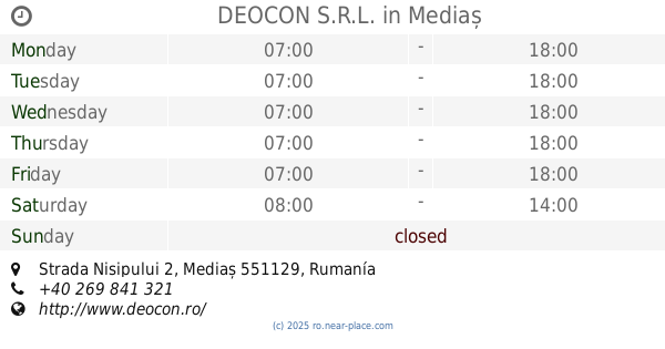
DEOCON S.R.L.
Strada Nisipului 2, Mediaș
Store
read more
757 m
DM
Mediaș
Store
read more
757 m
dm-drogerie markt
Mediaș
Store
read more
766 m
Deichman
Mediaș
Store
read more
842 m
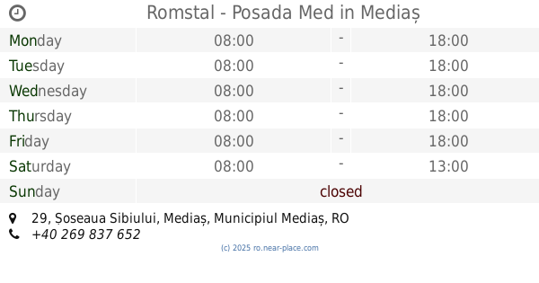
Romstal - Posada Med
Șoseaua Sibiului 29, Mediaș
Store
read more
845 m
AGRIAUTO MALL CENTER
Municipiul, Mediaș
Store
read more
1.113 km
Royal Colors Print
Șoseaua Sibiului nr 48, Mediaș
Store
read more
1.141 km
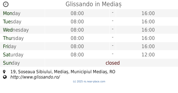
Glissando
Șoseaua Sibiului 19, Mediaș
Store
read more
2.101 km
Stanleybet
Str. M.Eminescu, nr.2, Mediaș
Store
read more
2.112 km
ZebraPay
Str Mihai Eminescu Nr 4, jud. Sibiu, Sibiu
Store
read more
2.137 km
Sex Shop Sibiu
Strada Petőfi Sándor 1, Mediaș
Store
read more
2.162 km
Papetarie Sc Marimas SRL
Strada Ştefan Ludwig Roth 4, Mediaș
Store
read more
2.193 km
Nanoline
Strada Păcii 7, Mediaș
Store
read more
📑
all categories
Accounting
Administrative area level 1
Administrative area level 2
Airport
Amusement park
Aquarium
Art gallery
Atm
Bakery
Bank
Bar
Beauty salon
Bicycle store
Book store
Bowling alley
Bus station
Cafe
Campground
Car dealer
Car rental
Car repair
Car wash
Casino
Cemetery
Church
City hall
Clothing store
Colloquial area
Convenience store
Country
Courthouse
Dentist
Department store
Doctor
Electrician
Electronics store
Embassy
Finance
Fire station
Florist
Food
Funeral home
Furniture store
Gas station
General contractor
Grocery or supermarket
Gym
Hair care
Hardware store
Health
Home goods store
Hospital
Insurance agency
Jewelry store
Laundry
Lawyer
Library
Light rail station
Liquor store
Local government office
Locality
Locksmith
Lodging
Meal delivery
Meal takeaway
Mosque
Movie rental
Movie theater
Moving company
Museum
Natural feature
Neighborhood
Night club
Painter
Park
Parking
Pet store
Pharmacy
Physiotherapist
Place of worship
Plumber
Point of interest
Police
Political
Post office
Premise
Real estate agency
Restaurant
Roofing contractor
Route
Rv park, camping
School
Shoe store
Shopping mall
Spa
Stadium
Storage
Store
Subpremise
Subway station
Supermarket
Synagogue
Taxi stand
Train station
Transit station
Travel agency
University
Veterinary care
Zoo
administrative area level 3
sublocality level 1
sublocality level 2
↑