Store nearby AdvancedBR
Romania
Store nearby AdvancedBR
AdvancedBR
București România
contacts phone
:
+40
Latitude:
44.4419306
, Longitude:
26.106922
read more
nearest Store
273 m
PlayBake by Eliza Gutau
Strada Maria Rosetti 28, București
Store
read more
397 m
ZebraPay
SHOP&GO MARIA ROSETTI 38, Str. Maria Rosetti, nr. 38, București
Store
read more
402 m
Miss H
Strada Italiană 25, București
Store
read more
542 m
Nano Bio Medical
Intrarea Armaşului 12, București
Store
read more
558 m
Marionnaud
Strada C. A. Rosetti 14-16, București
Store
read more
608 m
Legend Tattoo
Bulevardul Nicolae Bălcescu 18, București
Store
read more
623 m
Tabacioc
Bulevardul Nicolae Bălcescu 18, București
Store
read more
636 m
Legalizeit
Bulevardul Carol I 44-46, București
Store
read more
638 m
Romfilatelia
Strada Jean-Louis Calderon 1-5, București
Store
read more
652 m
Cofetaria Agapitos
Strada Jean-Louis Calderon, 5 (fosta, Strada Doctor Dimitrie D. Gerota 1, București
Store
read more
684 m
Argan Tree
Bulevardul Carol I 57, București
Store
read more
710 m
Daa
Bucharest
Store
read more
715 m
Floare de Colt
Calea Moșilor 127, București
Store
read more
762 m
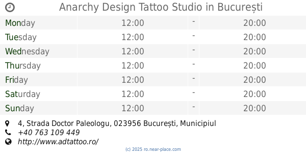
Anarchy Design Tattoo Studio
Strada Doctor Paleologu 4, București
Store
read more
802 m
Bucuria
Bulevardul General Gheorghe Magheru 28-30,București 010336, București
Store
read more
822 m
Băcănia Rod
Strada D. I. Mendeleev 2, București
Store
read more
839 m
Cofetăria Academiei
Strada Ion Câmpineanu 13, București
Store
read more
878 m
Picture Tattoo
Strada Ioan Vodă Caragea, București
Store
read more
887 m
Folder Romana
Bulevardul Dacia 26, București
Store
read more
927 m
Sertar magic
Calea Moșilor 90, București
Store
read more
930 m
Orange store
Constanza
Store
read more
939 m
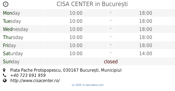
CISA CENTER
Piața Pache Protopopescu, București
Store
read more
992 m
Leonidas
Strada Doamnei 27, București
Store
read more
1.116 km
Copy Print Express
Strada Ion Bogdan 11A, București
Store
read more
1.337 km
Data Print Color (Xerox, Plafar)
Strada Ion Brezoianu 8, București
Store
read more
📑
all categories
Accounting
Administrative area level 1
Administrative area level 2
Airport
Amusement park
Aquarium
Art gallery
Atm
Bakery
Bank
Bar
Beauty salon
Bicycle store
Book store
Bowling alley
Bus station
Cafe
Campground
Car dealer
Car rental
Car repair
Car wash
Casino
Cemetery
Church
City hall
Clothing store
Colloquial area
Convenience store
Country
Courthouse
Dentist
Department store
Doctor
Electrician
Electronics store
Embassy
Finance
Fire station
Florist
Food
Funeral home
Furniture store
Gas station
General contractor
Grocery or supermarket
Gym
Hair care
Hardware store
Health
Home goods store
Hospital
Insurance agency
Jewelry store
Laundry
Lawyer
Library
Light rail station
Liquor store
Local government office
Locality
Locksmith
Lodging
Meal delivery
Meal takeaway
Mosque
Movie rental
Movie theater
Moving company
Museum
Natural feature
Neighborhood
Night club
Painter
Park
Parking
Pet store
Pharmacy
Physiotherapist
Place of worship
Plumber
Point of interest
Police
Political
Post office
Premise
Real estate agency
Restaurant
Roofing contractor
Route
Rv park, camping
School
Shoe store
Shopping mall
Spa
Stadium
Storage
Store
Subpremise
Subway station
Supermarket
Synagogue
Taxi stand
Train station
Transit station
Travel agency
University
Veterinary care
Zoo
administrative area level 3
sublocality level 1
sublocality level 2
↑