Restaurant nearby Big Food
Romania
Restaurant nearby Big Food
Big Food
Strada Vâlcele 58, Focșani Rumania
contacts phone
:
+40
Latitude:
45.6946749
, Longitude:
27.165198
read more
nearest Restaurant
588 m
Restaurant Perla Neagra
Unnamed Road, Focșani
Restaurant
read more
666 m
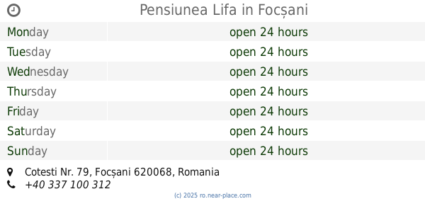
Pensiunea Lifa
Cotesti Nr. 79, Focșani
Restaurant
read more
692 m
Trattoria da Giuseppe
Focșani
Restaurant
read more
718 m
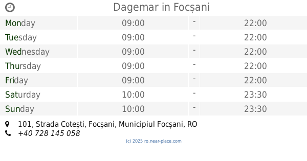
Dagemar
Strada Cotești 101, Focșani
Restaurant
read more
749 m
Restaurant Grand'Or
Strada Anghel Saligny, Focșani
Restaurant
read more
787 m
Restaurant Davids
Strada Cotești 101, Focșani
Restaurant
read more
800 m
club fabiola
Strada Petru Maior 4, Focșani
Restaurant
read more
808 m
Fast Food
Bulevardul Gării, Focșani
Restaurant
read more
849 m
Bun De Tot
Bulevardul Gării 26, Focșani
Restaurant
read more
918 m
Paco Food Factory
Bulevardul Gării 18 bis, Focșani
Restaurant
read more
956 m
Sweet Wedding & Ballroom Salon
Strada Cotești 101, Focșani
Restaurant
read more
962 m
Sir Alexander
Bulevardul Gării, Focșani
Restaurant
read more
984 m
Trattoria Verona
Bulevardul Gării, Focșani
Restaurant
read more
1.237 km
Intim
nr. 2, Strada Nicolae Bălcescu, Focșani
Restaurant
read more
1.34 km
Casa Veche
Strada Renașterii 10, Focșani
Restaurant
read more
1.541 km
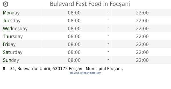
Bulevard Fast Food
Bulevardul Unirii 31, Focșani
Restaurant
read more
1.56 km
Zanfir Bistro
Strada Republicii 64, Focșani
Restaurant
read more
1.626 km
Ray Com Mode S.R.L.
Calea Moldovei 1, Focșani
Restaurant
read more
1.729 km
Dabo Doner Focsani
Strada Mihail Kogălniceanu 10-21, Focșani
Restaurant
read more
1.787 km
CIULEANDRA
Strada Simion Bărnuţiu, Focșani
Restaurant
read more
1.797 km
Foisorul Gongian
Strada Militari 62, Ceardac
Restaurant
read more
1.846 km
Pizzeria PLUS
Strada 1 Decembrie 1918 1, Focșani
Restaurant
read more
2.104 km
Pacific
Strada Ana Ipătescu 19, Focșani
Restaurant
read more
2.234 km
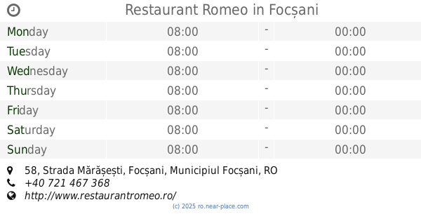
Restaurant Romeo
Strada Mărășești 58, Focșani
Restaurant
read more
2.272 km
Red International
Strada Mărășești 40, Focșani
Restaurant
read more
📑
all categories
Accounting
Administrative area level 1
Administrative area level 2
Airport
Amusement park
Aquarium
Art gallery
Atm
Bakery
Bank
Bar
Beauty salon
Bicycle store
Book store
Bowling alley
Bus station
Cafe
Campground
Car dealer
Car rental
Car repair
Car wash
Casino
Cemetery
Church
City hall
Clothing store
Colloquial area
Convenience store
Country
Courthouse
Dentist
Department store
Doctor
Electrician
Electronics store
Embassy
Finance
Fire station
Florist
Food
Funeral home
Furniture store
Gas station
General contractor
Grocery or supermarket
Gym
Hair care
Hardware store
Health
Home goods store
Hospital
Insurance agency
Jewelry store
Laundry
Lawyer
Library
Light rail station
Liquor store
Local government office
Locality
Locksmith
Lodging
Meal delivery
Meal takeaway
Mosque
Movie rental
Movie theater
Moving company
Museum
Natural feature
Neighborhood
Night club
Painter
Park
Parking
Pet store
Pharmacy
Physiotherapist
Place of worship
Plumber
Point of interest
Police
Political
Post office
Premise
Real estate agency
Restaurant
Roofing contractor
Route
Rv park, camping
School
Shoe store
Shopping mall
Spa
Stadium
Storage
Store
Subpremise
Subway station
Supermarket
Synagogue
Taxi stand
Train station
Transit station
Travel agency
University
Veterinary care
Zoo
administrative area level 3
sublocality level 1
sublocality level 2
↑