Pharmacy nearby Catena
Romania
Pharmacy nearby Catena
Catena
Bulevardul București, Ploiești Rumänien
contacts phone
:
+40
Latitude:
44.9213206
, Longitude:
26.0323669
read more
nearest Pharmacy
184 m
Maxi-Farma
Blocul 8A, Bulevardul București 9, Ploiești
Pharmacy
read more
391 m
Catena
Bulevardul București 24A, Ploiești
Pharmacy
read more
414 m
Sensiblu
12 a, Bulevardul București 33, Ploiești
Pharmacy
read more
567 m
Catena
Ploiești Sud, Ploiești
Pharmacy
read more
646 m
Maxi Farma
Bloc F, Strada Veronica Micle 1, Ploiești
Pharmacy
read more
648 m
Sensiblu
Strada Veronica Micle 1, Ploiești
Pharmacy
read more
797 m
Farmacia DONA
Ploiești
Pharmacy
read more
1.114 km
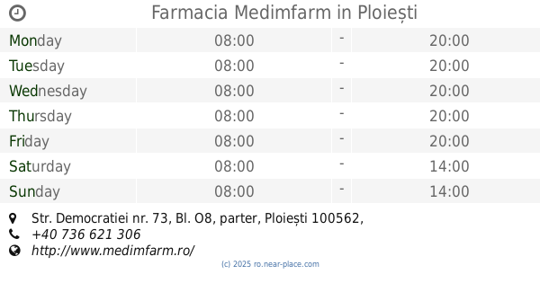
Farmacia Medimfarm
Str. Democratiei nr. 73, Bl. O8, parter, Ploiești
Pharmacy
read more
1.352 km
Farmex
Strada Democrației 56, Ploiești
Pharmacy
read more
1.518 km
FARMACIA FIOLY SRL
Strada Rudului 92, Ploiești
Pharmacy
read more
1.598 km
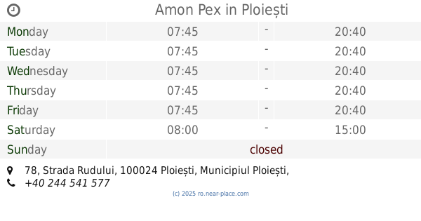
Amon Pex
Strada Rudului 78, Ploiești
Pharmacy
read more
2.034 km
Farmacia Medimfarm
Str. Stefan cel Mare, Nr. 2, Ploiești
Pharmacy
read more
2.074 km
Sensiblu
Strada Gheorghe Lazăr, Ploiești
Pharmacy
read more
2.078 km
Farmacia DONA
Piața Victoriei 4, Ploiești
Pharmacy
read more
2.207 km
Farmacia Pro - Sana 1
Str. Mihai Bravu nr. 173, Bl. 4A, Ploiești
Pharmacy
read more
2.241 km
Maxi Farma
Aleea Chimiei, Ploiești
Pharmacy
read more
2.318 km
Sensiblu
Bulevardul Independenței 15, Ploiești
Pharmacy
read more
2.348 km
Amon Pex
Strada Cuza Vodă, Ploiești
Pharmacy
read more
2.533 km
Sensiblu
Strada Griviței 2, Ploiești
Pharmacy
read more
2.593 km
Farmacia De Acasa
Centru, Ploiești
Pharmacy
read more
2.648 km
Dona
Strada George Coșbuc 13, Ploiești
Pharmacy
read more
2.723 km
Amon Pex
Strada Gheorghe Grigore Cantacuzino 145, Ploiești
Pharmacy
read more
2.724 km
Maxi Farma
Bloc 4, Strada General Vasile Milea 9, Ploiești
Pharmacy
read more
3.572 km
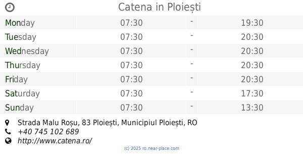
Catena
Strada Malu Roșu, Ploiești
Pharmacy
read more
4 km
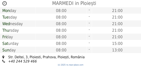
MARMEDI
Str. Deltei, 3, Ploiesti, Prahova, Ploiești
Pharmacy
read more
📑
all categories
Accounting
Administrative area level 1
Administrative area level 2
Airport
Amusement park
Aquarium
Art gallery
Atm
Bakery
Bank
Bar
Beauty salon
Bicycle store
Book store
Bowling alley
Bus station
Cafe
Campground
Car dealer
Car rental
Car repair
Car wash
Casino
Cemetery
Church
City hall
Clothing store
Colloquial area
Convenience store
Country
Courthouse
Dentist
Department store
Doctor
Electrician
Electronics store
Embassy
Finance
Fire station
Florist
Food
Funeral home
Furniture store
Gas station
General contractor
Grocery or supermarket
Gym
Hair care
Hardware store
Health
Home goods store
Hospital
Insurance agency
Jewelry store
Laundry
Lawyer
Library
Light rail station
Liquor store
Local government office
Locality
Locksmith
Lodging
Meal delivery
Meal takeaway
Mosque
Movie rental
Movie theater
Moving company
Museum
Natural feature
Neighborhood
Night club
Painter
Park
Parking
Pet store
Pharmacy
Physiotherapist
Place of worship
Plumber
Point of interest
Police
Political
Post office
Premise
Real estate agency
Restaurant
Roofing contractor
Route
Rv park, camping
School
Shoe store
Shopping mall
Spa
Stadium
Storage
Store
Subpremise
Subway station
Supermarket
Synagogue
Taxi stand
Train station
Transit station
Travel agency
University
Veterinary care
Zoo
administrative area level 3
sublocality level 1
sublocality level 2
↑