Park nearby Kids Park
Romania
Park nearby Kids Park
Kids Park
Strada Râmnicu Vâlcea 3, București Rumänien
contacts phone
:
+40
Latitude:
44.4185133
, Longitude:
26.140105
read more
nearest Park
716 m
Playground Sector 3
Unnamed Road, București
Park
read more
735 m
de joaca pentru copii
Sector 3
Park
read more
745 m
Fruit and vegetable market
Aleea Jieneasca, București
Park
read more
745 m
Piața de legume și fructe
Aleea Jieneasca, București
Park
read more
855 m
Amenajari Gradini Bucuresti-Ilfov
Strada Brăilița 3, București
Park
read more
963 m
Gradina botanica (sera)
Titan, Bucharest
Park
read more
963 m
Gradina botanica (sera)
Titan, București
Park
read more
1.154 km
Rosarium
Strada Câmpia Libertății, București
Park
read more
1.22 km
Insula Artelor
Sector 3
Park
read more
1.22 km
Insula Artelor
Sektor 3
Park
read more
1.286 km
Insula Câinilor
Titan, București
Park
read more
1.32 km
Parcul Alexandru Ioan Cuza
Titan, București
Park
read more
1.32 km
Alexandru Ioan Cuza Park
Titan, Bucharest
Park
read more
1.406 km
Insula Cățeilor
Alee Parc, București
Park
read more
1.482 km
Ilioara Micropark
Strada Ilioara 6, București
Park
read more
1.616 km
Parcul Gheorghe Petrașcu
Titan, Bucharest
Park
read more
1.693 km
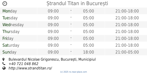
Ștrandul Titan
Bulevardul Nicolae Grigorescu, București
Park
read more
1.892 km
Parc Topoganul de ciment
Sector 3
Park
read more
1.894 km
Dog Park Nerva Traian
Sektor 3
Park
read more
1.894 km
Dog Park Nerva Traian
Sector 3
Park
read more
1.956 km
Ștrandul CARA Titan
Bulevardul Nicolae Grigorescu, București
Park
read more
1.977 km
Delta Vacaresti
București
Park
read more
2.325 km
Parcul Lumea Copiilor
București
Park
read more
2.439 km
Parc public
Aleea Budacu, București
Park
read more
2.563 km
Parcul Sfântul Ștefan
Sector 2
Park
read more
📑
all categories
Accounting
Administrative area level 1
Administrative area level 2
Airport
Amusement park
Aquarium
Art gallery
Atm
Bakery
Bank
Bar
Beauty salon
Bicycle store
Book store
Bowling alley
Bus station
Cafe
Campground
Car dealer
Car rental
Car repair
Car wash
Casino
Cemetery
Church
City hall
Clothing store
Colloquial area
Convenience store
Country
Courthouse
Dentist
Department store
Doctor
Electrician
Electronics store
Embassy
Finance
Fire station
Florist
Food
Funeral home
Furniture store
Gas station
General contractor
Grocery or supermarket
Gym
Hair care
Hardware store
Health
Home goods store
Hospital
Insurance agency
Jewelry store
Laundry
Lawyer
Library
Light rail station
Liquor store
Local government office
Locality
Locksmith
Lodging
Meal delivery
Meal takeaway
Mosque
Movie rental
Movie theater
Moving company
Museum
Natural feature
Neighborhood
Night club
Painter
Park
Parking
Pet store
Pharmacy
Physiotherapist
Place of worship
Plumber
Point of interest
Police
Political
Post office
Premise
Real estate agency
Restaurant
Roofing contractor
Route
Rv park, camping
School
Shoe store
Shopping mall
Spa
Stadium
Storage
Store
Subpremise
Subway station
Supermarket
Synagogue
Taxi stand
Train station
Transit station
Travel agency
University
Veterinary care
Zoo
administrative area level 3
sublocality level 1
sublocality level 2
↑