Night club nearby Night Club Malibu
Romania
Night club nearby Night Club Malibu
Night Club Malibu
Strada Avram Iancu 8, Brașov Rumania
contacts phone
:
+40
Latitude:
45.6537982
, Longitude:
25.593735
read more
nearest Night club
135 m
Macovi Club S.R.L.
Str. Avram Iancu, 32, Brasov, Brasov, 500086, Brașov
Night club
read more
769 m
Dreams Night Club
Strada Avram Iancu 76, Brașov
Night club
read more
834 m
Club Arta
Strada Grădinarilor 13, Brașov
Night club
read more
866 m
Egreta
Strada Aurel Vlaicu 43, Brașov
Night club
read more
973 m
Black & Silver
Bulevardul 15 Noiembrie 9, Brașov
Night club
read more
1.019 km
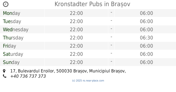
Kronstadter Pubs
Bulevardul Eroilor 17, Brașov
Night club
read more
1.03 km
Times
Bulevardul Eroilor 17, Brașov
Night club
read more
1.161 km
Studio 80
Strada Mureșenilor 11-13, Brașov
Night club
read more
1.241 km
Move Club
Strada Mihail Kogălniceanu 15, Brașov
Night club
read more
1.257 km
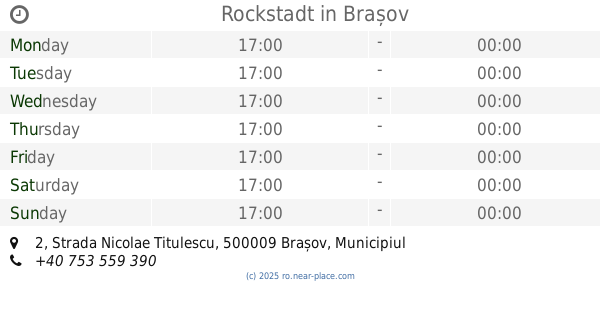
Rockstadt
Strada Nicolae Titulescu 2, Brașov
Night club
read more
1.262 km
Cafe 13
Strada Republicii 13, Brașov
Night club
read more
1.29 km
Il Caminetto
Piața Sfatului 27, Brașov
Night club
read more
1.316 km
4rooms
Bloc C2, Strada Mihail Kogălniceanu 13, Brașov
Night club
read more
1.531 km
Vanilla Lounge & Games
Unirea Shopping Center, Etaj 3, Bulevardul Gării 3A, Brașov
Night club
read more
2.225 km
Hacienda
Strada Carpaților 17, Brașov
Night club
read more
2.348 km
La Lăutari
Strada Brândușelor 74, Brașov
Night club
read more
2.696 km
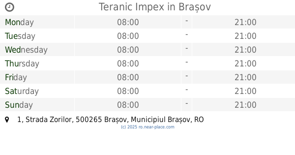
Teranic Impex
Strada Zorilor 1, Brașov
Night club
read more
2.78 km
Vanilla Urban Lounge
Strada Zaharia Stancu 1, Brașov
Night club
read more
3.14 km
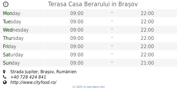
Terasa Casa Berarului
Strada Jupiter, Brașov
Night club
read more
4.594 km
Vanilla Coffee
Calea București 107, Brașov
Night club
read more
12.542 km
Club Medieval
DN1 90, Codlea
Night club
read more
27.194 km
Club Paradise
Sfântu Gheorghe
Night club
read more
28.466 km
Öcsi bácsi borozója
Sfântu Gheorghe
Night club
read more
28.556 km
Baroque
Sfântu Gheorghe
Night club
read more
29.421 km
Pisztrangászat
Șugaș Băi
Night club
read more
📑
all categories
Accounting
Administrative area level 1
Administrative area level 2
Airport
Amusement park
Aquarium
Art gallery
Atm
Bakery
Bank
Bar
Beauty salon
Bicycle store
Book store
Bowling alley
Bus station
Cafe
Campground
Car dealer
Car rental
Car repair
Car wash
Casino
Cemetery
Church
City hall
Clothing store
Colloquial area
Convenience store
Country
Courthouse
Dentist
Department store
Doctor
Electrician
Electronics store
Embassy
Finance
Fire station
Florist
Food
Funeral home
Furniture store
Gas station
General contractor
Grocery or supermarket
Gym
Hair care
Hardware store
Health
Home goods store
Hospital
Insurance agency
Jewelry store
Laundry
Lawyer
Library
Light rail station
Liquor store
Local government office
Locality
Locksmith
Lodging
Meal delivery
Meal takeaway
Mosque
Movie rental
Movie theater
Moving company
Museum
Natural feature
Neighborhood
Night club
Painter
Park
Parking
Pet store
Pharmacy
Physiotherapist
Place of worship
Plumber
Point of interest
Police
Political
Post office
Premise
Real estate agency
Restaurant
Roofing contractor
Route
Rv park, camping
School
Shoe store
Shopping mall
Spa
Stadium
Storage
Store
Subpremise
Subway station
Supermarket
Synagogue
Taxi stand
Train station
Transit station
Travel agency
University
Veterinary care
Zoo
administrative area level 3
sublocality level 1
sublocality level 2
↑