Lodging nearby Valea Cu Ponei
Romania
Lodging nearby Valea Cu Ponei
Valea Cu Ponei
Vlădeni Romania
contacts phone
:
+40
Latitude:
45.7540487
, Longitude:
25.3009521
read more
nearest Lodging
1.504 km
Popasul Briliant
Km 204, DN1, Vlădeni
Lodging
read more
3.84 km
Roadhouse
DN1
Lodging
read more
5.622 km
Cabana Geamăna
Vlădeni
Lodging
read more
5.88 km
T.S. Wonderland
Zeiden
Lodging
read more
5.88 km
T.S. Wonderland
Codlea
Lodging
read more
7.13 km
Cabana Păstrăva
Lodging
read more
9.176 km
Băile Perșani
DN1
Lodging
read more
10.113 km
Pensiunea Confort Morosanu
Sinca Veche Nr 50, Șinca Veche
Lodging
read more
10.494 km
Hanul Roua Sanzienelor Şinca Nouă
Lodging
read more
10.507 km
Pensiunea Confort Morosanu
Șinca
Lodging
read more
11.875 km
Moara cu Noroc
Ohaba
Lodging
read more
12.063 km
Chalet Den urşillor
Șinca Nouă
Lodging
read more
12.798 km
Pensiunea Puiu Popa
95, Strada Lungă, Codlea
Lodging
read more
13.395 km
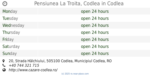
Pensiunea La Troita, Codlea
Strada Hălchiului 20, Codlea
Lodging
read more
14.763 km
Casa Cristalul Muntilor
Scurtila 555, Poiana Mărului
Lodging
read more
14.886 km
Pensiunea Sapte Brazi
Poiana Mărului
Lodging
read more
16.263 km
Casa Manitiu
STR. PRINCIPALA, 310, Com. Vulcan, Brasov, 507270, Vulcan
Lodging
read more
16.585 km
Wolkendorf BioHotel & SPA
Vulcan
Lodging
read more
19.584 km
Cristian House
Str. Morii Nr.105 A Cristian, Cristian
Lodging
read more
19.666 km
garsoniera
Strada Morii 38, Cristian
Lodging
read more
19.725 km
Neustadt Villa
Strada Morii 14, Cristian
Lodging
read more
20.018 km
Vila Old Cars
Cazare, Strada Lungă 210, Cristian
Lodging
read more
20.093 km
Apartament la casa in Cristian Brasov
numar 19, Strada Andrei Mureșanu, Cristian
Lodging
read more
20.434 km
Vila Nicolai
Strada George Coșbuc, 28 numarul 28, Cristian
Lodging
read more
20.446 km
Stoian
43,, Strada George Coșbuc, Cristian
Lodging
read more
📑
all categories
Accounting
Administrative area level 1
Administrative area level 2
Airport
Amusement park
Aquarium
Art gallery
Atm
Bakery
Bank
Bar
Beauty salon
Bicycle store
Book store
Bowling alley
Bus station
Cafe
Campground
Car dealer
Car rental
Car repair
Car wash
Casino
Cemetery
Church
City hall
Clothing store
Colloquial area
Convenience store
Country
Courthouse
Dentist
Department store
Doctor
Electrician
Electronics store
Embassy
Finance
Fire station
Florist
Food
Funeral home
Furniture store
Gas station
General contractor
Grocery or supermarket
Gym
Hair care
Hardware store
Health
Home goods store
Hospital
Insurance agency
Jewelry store
Laundry
Lawyer
Library
Light rail station
Liquor store
Local government office
Locality
Locksmith
Lodging
Meal delivery
Meal takeaway
Mosque
Movie rental
Movie theater
Moving company
Museum
Natural feature
Neighborhood
Night club
Painter
Park
Parking
Pet store
Pharmacy
Physiotherapist
Place of worship
Plumber
Point of interest
Police
Political
Post office
Premise
Real estate agency
Restaurant
Roofing contractor
Route
Rv park, camping
School
Shoe store
Shopping mall
Spa
Stadium
Storage
Store
Subpremise
Subway station
Supermarket
Synagogue
Taxi stand
Train station
Transit station
Travel agency
University
Veterinary care
Zoo
administrative area level 3
sublocality level 1
sublocality level 2
↑