Lodging nearby Madéfalvi Menedékház
Romania
Lodging nearby Madéfalvi Menedékház
Madéfalvi Menedékház
Siculeni Rumunia
contacts phone
:
+40
Latitude:
46.4392977
, Longitude:
25.7268833
read more
nearest Lodging
2.669 km
Zoli Vendégház
Fő út 201, Racu
Lodging
read more
2.73 km
Cserekert Fogadó
185
Lodging
read more
3.39 km
White Dove Pension
Csaracso 56 A, Ciaracio
Lodging
read more
3.404 km
Pension Amade
Siculeni
Lodging
read more
4.575 km
Vándor Székely Rönkház
Racu
Lodging
read more
5.662 km
Erdélyi Vendégház
248, Văcărești
Lodging
read more
6.058 km
Chalet Lali
Csikmadaras, Egervára u., 396, 537071, Mădăraș
Lodging
read more
6.62 km
Onodilak Vendégház
Malom utca 54., Bîrzava
Lodging
read more
7.299 km
Pensiunea Moara Zsigmond
Mădăraș
Lodging
read more
8.571 km
Flamingo
Strada Toplița 141A, Miercurea Ciuc
Lodging
read more
8.649 km
Medveles - Hargita, Piricske
Lodging
read more
9.443 km
KASSAY FOGADÓ
Gyimesi út 74, Frumoasa
Lodging
read more
9.591 km
Sunny Creek Cottage
Pauleni-Ciuc 103, Păuleni-Ciuc
Lodging
read more
10.065 km
Jakab Antal Ház
Strada Szék 147, Miercurea Ciuc
Lodging
read more
10.32 km
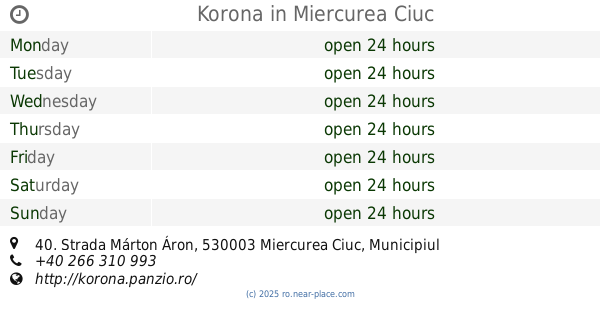
Korona
Strada Márton Áron 40, Miercurea Ciuc
Lodging
read more
10.413 km
Csiki Hotel
Strada Márton Áron 34, Miercurea Ciuc
Lodging
read more
10.614 km
Hunguest Hotel Fenyő
Strada Nicolae Bălcescu 11, Miercurea Ciuc
Lodging
read more
11.148 km
Casa de Vacanta Bicajanu
Strada Băilor Nr 25 (Szecseny), Miercurea Ciuc
Lodging
read more
11.493 km
Kwatera Do Wynajevia Buking.com
Strada Zsögödi Nagy Imre 4, Miercurea Ciuc
Lodging
read more
11.496 km
Fortuna Park Apartments
Strada Bradului 1, Miercurea Ciuc
Lodging
read more
12.582 km
Baki Vendeghaz
Strada Jigodin 27, Miercurea Ciuc
Lodging
read more
12.615 km
Betty Panzio
Strada Jigodin 5, Jigodin-Băi
Lodging
read more
12.849 km
Csillag Motel
Strada Brașovului 113, Miercurea Ciuc
Lodging
read more
15.989 km
Szellő Szálló
Sâncrăieni
Lodging
read more
16.524 km
Pensiunea Eszter Ház
nr. 728, Sâncrăieni
Lodging
read more
📑
all categories
Accounting
Administrative area level 1
Administrative area level 2
Airport
Amusement park
Aquarium
Art gallery
Atm
Bakery
Bank
Bar
Beauty salon
Bicycle store
Book store
Bowling alley
Bus station
Cafe
Campground
Car dealer
Car rental
Car repair
Car wash
Casino
Cemetery
Church
City hall
Clothing store
Colloquial area
Convenience store
Country
Courthouse
Dentist
Department store
Doctor
Electrician
Electronics store
Embassy
Finance
Fire station
Florist
Food
Funeral home
Furniture store
Gas station
General contractor
Grocery or supermarket
Gym
Hair care
Hardware store
Health
Home goods store
Hospital
Insurance agency
Jewelry store
Laundry
Lawyer
Library
Light rail station
Liquor store
Local government office
Locality
Locksmith
Lodging
Meal delivery
Meal takeaway
Mosque
Movie rental
Movie theater
Moving company
Museum
Natural feature
Neighborhood
Night club
Painter
Park
Parking
Pet store
Pharmacy
Physiotherapist
Place of worship
Plumber
Point of interest
Police
Political
Post office
Premise
Real estate agency
Restaurant
Roofing contractor
Route
Rv park, camping
School
Shoe store
Shopping mall
Spa
Stadium
Storage
Store
Subpremise
Subway station
Supermarket
Synagogue
Taxi stand
Train station
Transit station
Travel agency
University
Veterinary care
Zoo
administrative area level 3
sublocality level 1
sublocality level 2
↑