Gas station nearby Statie Peco Cristal
Romania
Gas station nearby Statie Peco Cristal
Statie Peco Cristal
Hudum Rumænien
contacts phone
:
+40
Latitude:
47.7350026
, Longitude:
26.6203039
read more
nearest Gas station
2.417 km
OMV
Strada Sucevei nr. 3, Botoșani
Gas station
read more
2.417 km
Statie de distributie carburanti OMV
Strada Sucevei nr. 3, Botoșani
Gas station
read more
2.497 km
OMV
Calea Națională 31, Botoșani
Gas station
read more
2.497 km
Statie de distributie carburanti OMV
Calea Națională 31, Botoșani
Gas station
read more
2.503 km
MOL Benzinkút
Calea Națională, Botoșani
Gas station
read more
2.503 km
MOL
Calea Națională, Botoșani
Gas station
read more
2.955 km
BBB
Calea Națională, Botoșani
Gas station
read more
3.163 km
Lukoil
Calea Națională 1A, Botoșani
Gas station
read more
3.445 km
Partener Rompetrol Botosani
Strada Mihai Eminescu 117, Botoșani
Gas station
read more
3.599 km
Țiriac Energy
Calea Națională, Botoșani
Gas station
read more
3.688 km
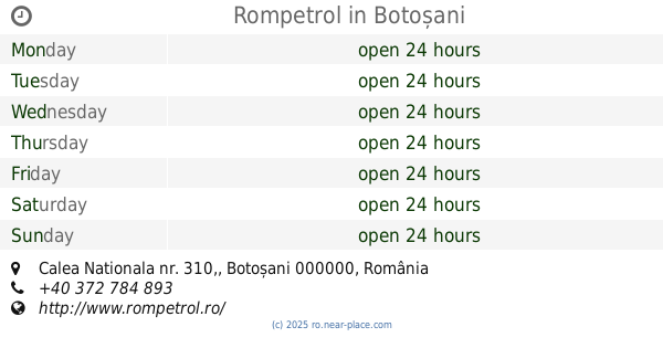
Rompetrol
Calea Nationala nr. 310,, Botoșani
Gas station
read more
3.75 km
Partener Rompetrol Botosani
Strada Independenței 1, Botoșani
Gas station
read more
3.855 km
Socar
Bulevardul Mihai Eminescu 193A, Botoșani
Gas station
read more
3.925 km
Petrom
Calea Națională nr. 142, Botoșani
Gas station
read more
4.028 km
Socar
Strada Independenței 26A, Botoșani
Gas station
read more
4.235 km
Lukoil
Calea Națională 156, Botoșani
Gas station
read more
4.482 km
BBB
Șoseaua Iașului, Botoșani
Gas station
read more
5.611 km
Cristal
DN29, Botoșani
Gas station
read more
6.193 km
Socar Răchiți
DN29, Răchiți
Gas station
read more
6.214 km
Partener Rompetrol Rachiti
Rachiti, DN29, Răchiți
Gas station
read more
9.507 km
ANDREEA
Com. Stauceni, Botosani, 717355, Stauceni
Gas station
read more
24.908 km
Oil Star S.R.L.
Com. Adâncata, Suceava, 727005, Adâncata
Gas station
read more
25.645 km
OMV
Strada Cuza Vodă nr. 65, Suceava
Gas station
read more
28.016 km
Mili Ghes
Bosanci
Gas station
read more
28.043 km
Peco
DJ208A, Bosanci
Gas station
read more
📑
all categories
Accounting
Administrative area level 1
Administrative area level 2
Airport
Amusement park
Aquarium
Art gallery
Atm
Bakery
Bank
Bar
Beauty salon
Bicycle store
Book store
Bowling alley
Bus station
Cafe
Campground
Car dealer
Car rental
Car repair
Car wash
Casino
Cemetery
Church
City hall
Clothing store
Colloquial area
Convenience store
Country
Courthouse
Dentist
Department store
Doctor
Electrician
Electronics store
Embassy
Finance
Fire station
Florist
Food
Funeral home
Furniture store
Gas station
General contractor
Grocery or supermarket
Gym
Hair care
Hardware store
Health
Home goods store
Hospital
Insurance agency
Jewelry store
Laundry
Lawyer
Library
Light rail station
Liquor store
Local government office
Locality
Locksmith
Lodging
Meal delivery
Meal takeaway
Mosque
Movie rental
Movie theater
Moving company
Museum
Natural feature
Neighborhood
Night club
Painter
Park
Parking
Pet store
Pharmacy
Physiotherapist
Place of worship
Plumber
Point of interest
Police
Political
Post office
Premise
Real estate agency
Restaurant
Roofing contractor
Route
Rv park, camping
School
Shoe store
Shopping mall
Spa
Stadium
Storage
Store
Subpremise
Subway station
Supermarket
Synagogue
Taxi stand
Train station
Transit station
Travel agency
University
Veterinary care
Zoo
administrative area level 3
sublocality level 1
sublocality level 2
↑