Cafe nearby Funky
Romania
Cafe nearby Funky
Funky
Calea București, Craiova România
contacts phone
:
+40
Latitude:
44.3128213
, Longitude:
23.8321996
read more
nearest Cafe
36 m
Aroma Café
Calea București, Craiova
Cafe
read more
45 m
Hedone
Calea București 80, Craiova
Cafe
read more
49 m
Doux Eclair
Calea București 80, Craiova
Cafe
read more
73 m
Zvon Cafe
Calea București 80, Craiova
Cafe
read more
94 m
Mon'soon Cafe
Calea București 80, Craiova
Cafe
read more
103 m
Starbucks
Calea București 80, Craiova
Cafe
read more
994 m
Nanterre Drinks & Coffee
Strada Nanterre 90, Craiova
Cafe
read more
1.011 km
Salsa Dynamyk
Strada Petre Ispirescu 44, Craiova
Cafe
read more
1.432 km
Cafe Irini's
Strada Vasile Alecsandri 174, Craiova
Cafe
read more
1.479 km
Blues Cafe
Strada Dezrobirii, Craiova
Cafe
read more
1.79 km
Refresh
Strada Alexandru Ioan Cuza 12, Craiova
Cafe
read more
2.254 km
Pizza MyWay
Strada România Muncitoare 55, Craiova
Cafe
read more
2.439 km
Secret Place
Bloc D, Strada Alexandru Ioan Cuza 46, Craiova
Cafe
read more
2.476 km
Ago Violin
Bulevardul Carol I, Craiova
Cafe
read more
2.595 km
Fun / Caffe
Strada Frații Buzești 25, Craiova
Cafe
read more
2.619 km
History
Strada România Muncitoare 32A, Craiova
Cafe
read more
2.641 km
Come Back Caffe & Lounge
Strada România Muncitoare 3, Craiova
Cafe
read more
2.69 km
Rendez Vous
Strada Panait Moșoiu 2, Craiova
Cafe
read more
2.742 km
I Love Cakes
Strada Olteț 9, Craiova
Cafe
read more
2.782 km
Love Story
Bulevardul Gheorghe Chițu 4, Craiova
Cafe
read more
2.816 km
5 to go
Bloc 156, Strada Alexandru Ioan Cuza 9, Craiova
Cafe
read more
2.826 km
Leonidas
Bloc 156, Strada Alexandru Ioan Cuza 9, Craiova
Cafe
read more
2.832 km
ecler
Strada Theodor Aman 1, Craiova
Cafe
read more
2.937 km
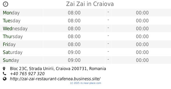
Zai Zai
Bloc 23C, Strada Unirii, Craiova
Cafe
read more
2.978 km
Cin Cin
Calea Unirii, Craiova
Cafe
read more
📑
all categories
Accounting
Administrative area level 1
Administrative area level 2
Airport
Amusement park
Aquarium
Art gallery
Atm
Bakery
Bank
Bar
Beauty salon
Bicycle store
Book store
Bowling alley
Bus station
Cafe
Campground
Car dealer
Car rental
Car repair
Car wash
Casino
Cemetery
Church
City hall
Clothing store
Colloquial area
Convenience store
Country
Courthouse
Dentist
Department store
Doctor
Electrician
Electronics store
Embassy
Finance
Fire station
Florist
Food
Funeral home
Furniture store
Gas station
General contractor
Grocery or supermarket
Gym
Hair care
Hardware store
Health
Home goods store
Hospital
Insurance agency
Jewelry store
Laundry
Lawyer
Library
Light rail station
Liquor store
Local government office
Locality
Locksmith
Lodging
Meal delivery
Meal takeaway
Mosque
Movie rental
Movie theater
Moving company
Museum
Natural feature
Neighborhood
Night club
Painter
Park
Parking
Pet store
Pharmacy
Physiotherapist
Place of worship
Plumber
Point of interest
Police
Political
Post office
Premise
Real estate agency
Restaurant
Roofing contractor
Route
Rv park, camping
School
Shoe store
Shopping mall
Spa
Stadium
Storage
Store
Subpremise
Subway station
Supermarket
Synagogue
Taxi stand
Train station
Transit station
Travel agency
University
Veterinary care
Zoo
administrative area level 3
sublocality level 1
sublocality level 2
↑