Cafe nearby District Cafe
Romania
Cafe nearby District Cafe
District Cafe
Centru, Craiova Rumania
contacts phone
:
+40
Latitude:
44.313234
, Longitude:
23.793039
read more
nearest Cafe
362 m
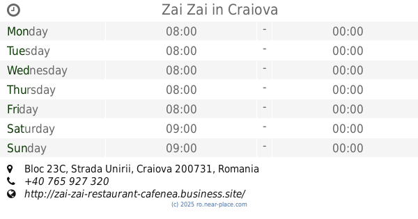
Zai Zai
Bloc 23C, Strada Unirii, Craiova
Cafe
read more
419 m
Ristretto To Go CoffeeShop
Strada Madona Dudu 25, Craiova
Cafe
read more
430 m
Cafea adevărată
Strada Madona Dudu, Craiova
Cafe
read more
471 m
Cin Cin
Calea Unirii, Craiova
Cafe
read more
486 m
Starbucks
Calea Unirii 14, Craiova
Cafe
read more
516 m
Theodor Caffe
Strada Theodor Aman 4, Craiova
Cafe
read more
552 m
Playstation Craiova
Strada Frații Buzești 25, Craiova
Cafe
read more
552 m
Fun / Caffe
Strada Frații Buzești 25, Craiova
Cafe
read more
593 m
ECLER By DesserTime
Centru, Craiova
Cafe
read more
620 m
ecler
Strada Theodor Aman 1, Craiova
Cafe
read more
647 m
I Love Cakes
Strada Olteț 9, Craiova
Cafe
read more
656 m
Cadouri•Dulciuri•Flori
Centru, Craiova
Cafe
read more
657 m
Love Story
Bulevardul Gheorghe Chițu 4, Craiova
Cafe
read more
697 m
Kabina
Strada Alexandru Ioan Cuza 4, Craiova
Cafe
read more
701 m
Come Back Caffe & Lounge
Strada România Muncitoare 3, Craiova
Cafe
read more
707 m
5 to go
Bloc 156, Strada Alexandru Ioan Cuza 9, Craiova
Cafe
read more
711 m
History
Strada România Muncitoare 32A, Craiova
Cafe
read more
722 m
Patiseria-Shaormeria Merci
Strada Mihai Viteazul 14, Craiova
Cafe
read more
753 m
Rendez Vous
Strada Panait Moșoiu 2, Craiova
Cafe
read more
753 m
SC Servomont Import - Export SRL
Strada Panait Moșoiu 2, Craiova
Cafe
read more
758 m
Leonidas
Bloc 156, Strada Alexandru Ioan Cuza 9, Craiova
Cafe
read more
838 m
Seven Bar
Strada Arieș 1, Craiova
Cafe
read more
901 m
Secret Place
Bloc D, Strada Alexandru Ioan Cuza 46, Craiova
Cafe
read more
972 m
Yes Or No
Bloc M14, Strada Alexandru Ioan Cuza 17, Craiova
Cafe
read more
1.022 km
Pizza MyWay
Strada România Muncitoare 55, Craiova
Cafe
read more
📑
all categories
Accounting
Administrative area level 1
Administrative area level 2
Airport
Amusement park
Aquarium
Art gallery
Atm
Bakery
Bank
Bar
Beauty salon
Bicycle store
Book store
Bowling alley
Bus station
Cafe
Campground
Car dealer
Car rental
Car repair
Car wash
Casino
Cemetery
Church
City hall
Clothing store
Colloquial area
Convenience store
Country
Courthouse
Dentist
Department store
Doctor
Electrician
Electronics store
Embassy
Finance
Fire station
Florist
Food
Funeral home
Furniture store
Gas station
General contractor
Grocery or supermarket
Gym
Hair care
Hardware store
Health
Home goods store
Hospital
Insurance agency
Jewelry store
Laundry
Lawyer
Library
Light rail station
Liquor store
Local government office
Locality
Locksmith
Lodging
Meal delivery
Meal takeaway
Mosque
Movie rental
Movie theater
Moving company
Museum
Natural feature
Neighborhood
Night club
Painter
Park
Parking
Pet store
Pharmacy
Physiotherapist
Place of worship
Plumber
Point of interest
Police
Political
Post office
Premise
Real estate agency
Restaurant
Roofing contractor
Route
Rv park, camping
School
Shoe store
Shopping mall
Spa
Stadium
Storage
Store
Subpremise
Subway station
Supermarket
Synagogue
Taxi stand
Train station
Transit station
Travel agency
University
Veterinary care
Zoo
administrative area level 3
sublocality level 1
sublocality level 2
↑