Bus station nearby Statie Autobuz
Romania
Bus station nearby Statie Autobuz
Statie Autobuz
Smârdan Rumunia
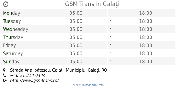
contacts phone
:
+40
Latitude:
45.4748971
, Longitude:
27.9425776
read more
nearest Bus station
5.707 km
SRPGC
Galați
Bus station
read more
6.134 km
Cimitir Israelit
Galați
Bus station
read more
7.731 km
Statie Transurb
Țiglina 3, Galați
Bus station
read more
7.786 km
Str.Aurel Vlaicu
Bulevardul George Coșbuc, Galați
Bus station
read more
8.125 km
Casa Roşie
Bulevardul Siderurgiștilor, Galați
Bus station
read more
8.275 km
Scoala 40
Strada Oltului, Galați
Bus station
read more
8.297 km
Penny Market
Strada Barboşi 7, Galați
Bus station
read more
8.471 km
Farmacia Hygeea
Strada Brăilei, Galați
Bus station
read more
8.477 km
Galați, Galați (Arcada)
Romania
Bus station
read more
8.478 km
Țiglina II
Strada Brăilei, Galați
Bus station
read more
8.512 km
Ţiglina 1
Țiglina 1, Galați
Bus station
read more
8.764 km
Capat Troleu
Strada Oțelarilor, Galați
Bus station
read more
8.89 km
Orăşelul copiilor
Strada Regimentul 11 Siret, Galați
Bus station
read more
8.902 km
CEC Țiglina II
Strada Brăilei, Galați
Bus station
read more
9.276 km
Tribunal
Bulevardul Prelungirea Coşbuc, Galați
Bus station
read more
9.276 km
Piata Mare
Galați
Bus station
read more
9.33 km
Bloc E6
Strada Regimentul 11 Siret, Galați
Bus station
read more
9.338 km
Basarabiei
Strada Basarabiei 4, Galați
Bus station
read more
9.535 km
Parfumul Teilor
Strada Domnească, Galați
Bus station
read more
9.626 km
Potcoava de Aur
Galați
Bus station
read more
9.73 km
Universitate
Strada Domnească, Galați
Bus station
read more
9.822 km
Parc Eminescu
Strada Domnească, Galați
Bus station
read more
9.906 km
GSM Trans
Strada Ana Ipătescu, Galați
Bus station
read more
10.038 km
Complex Spicul
Strada Navelor, Galați
Bus station
read more
10.459 km
Navrom
Strada Portului, Galați
Bus station
read more
📑
all categories
Accounting
Administrative area level 1
Administrative area level 2
Airport
Amusement park
Aquarium
Art gallery
Atm
Bakery
Bank
Bar
Beauty salon
Bicycle store
Book store
Bowling alley
Bus station
Cafe
Campground
Car dealer
Car rental
Car repair
Car wash
Casino
Cemetery
Church
City hall
Clothing store
Colloquial area
Convenience store
Country
Courthouse
Dentist
Department store
Doctor
Electrician
Electronics store
Embassy
Finance
Fire station
Florist
Food
Funeral home
Furniture store
Gas station
General contractor
Grocery or supermarket
Gym
Hair care
Hardware store
Health
Home goods store
Hospital
Insurance agency
Jewelry store
Laundry
Lawyer
Library
Light rail station
Liquor store
Local government office
Locality
Locksmith
Lodging
Meal delivery
Meal takeaway
Mosque
Movie rental
Movie theater
Moving company
Museum
Natural feature
Neighborhood
Night club
Painter
Park
Parking
Pet store
Pharmacy
Physiotherapist
Place of worship
Plumber
Point of interest
Police
Political
Post office
Premise
Real estate agency
Restaurant
Roofing contractor
Route
Rv park, camping
School
Shoe store
Shopping mall
Spa
Stadium
Storage
Store
Subpremise
Subway station
Supermarket
Synagogue
Taxi stand
Train station
Transit station
Travel agency
University
Veterinary care
Zoo
administrative area level 3
sublocality level 1
sublocality level 2
↑