Bus station nearby Liceul de arta
Romania
Bus station nearby Liceul de arta
Liceul de arta
Strada Domnească, Galați România
contacts phone
:
+40
Latitude:
45.4452286
, Longitude:
28.0548495
read more
nearest Bus station
47 m
Basarabiei
Strada Basarabiei 4, Galați
Bus station
read more
288 m
Parfumul Teilor
Strada Domnească, Galați
Bus station
read more
605 m
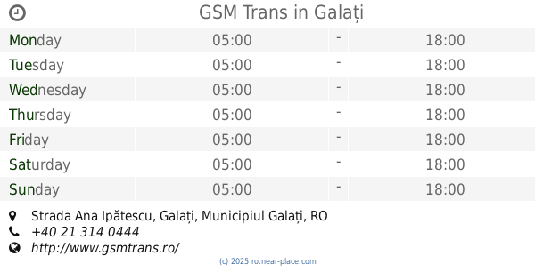
GSM Trans
Strada Ana Ipătescu, Galați
Bus station
read more
657 m
Baia Comunalului
Galați
Bus station
read more
680 m
Universitate
Strada Domnească, Galați
Bus station
read more
913 m
Piata Mare
Galați
Bus station
read more
1.012 km
Parc Eminescu
Strada Domnească, Galați
Bus station
read more
1.227 km
Centru
Strada Nicolae Bălcescu, Galați
Bus station
read more
1.424 km
Potcoava de Aur
Galați
Bus station
read more
1.446 km
Complex Spicul
Strada Navelor, Galați
Bus station
read more
1.515 km
Cimitirul Eternitatea
Bulevardul George Coșbuc, Galați
Bus station
read more
1.518 km
Liceul de Marina
Galați
Bus station
read more
1.583 km
Str.Aurel Vlaicu
Bulevardul George Coșbuc, Galați
Bus station
read more
1.6 km
Navrom
Strada Portului, Galați
Bus station
read more
1.611 km
Str.Tecuci
Bulevardul George Coșbuc, Galați
Bus station
read more
1.697 km
Agenția CFR
Strada Brăilei, Galați
Bus station
read more
1.754 km
Mazepa
Strada Brăilei, Galați
Bus station
read more
1.892 km
Str.M.Kogalniceanu
Bulevardul George Coșbuc, Galați
Bus station
read more
2.178 km
Bănci
Strada Brăilei, Galați
Bus station
read more
2.238 km
Casa de Cultură
Bulevardul George Coșbuc, Galați
Bus station
read more
2.373 km
CEC Țiglina II
Strada Brăilei, Galați
Bus station
read more
2.498 km
Tribunal
Bulevardul Prelungirea Coşbuc, Galați
Bus station
read more
2.843 km
Ţiglina 1
Țiglina 1, Galați
Bus station
read more
2.91 km
Casa Roşie
Bulevardul Siderurgiștilor, Galați
Bus station
read more
4.125 km
Farmacia Hygeea
Strada Brăilei, Galați
Bus station
read more
📑
all categories
Accounting
Administrative area level 1
Administrative area level 2
Airport
Amusement park
Aquarium
Art gallery
Atm
Bakery
Bank
Bar
Beauty salon
Bicycle store
Book store
Bowling alley
Bus station
Cafe
Campground
Car dealer
Car rental
Car repair
Car wash
Casino
Cemetery
Church
City hall
Clothing store
Colloquial area
Convenience store
Country
Courthouse
Dentist
Department store
Doctor
Electrician
Electronics store
Embassy
Finance
Fire station
Florist
Food
Funeral home
Furniture store
Gas station
General contractor
Grocery or supermarket
Gym
Hair care
Hardware store
Health
Home goods store
Hospital
Insurance agency
Jewelry store
Laundry
Lawyer
Library
Light rail station
Liquor store
Local government office
Locality
Locksmith
Lodging
Meal delivery
Meal takeaway
Mosque
Movie rental
Movie theater
Moving company
Museum
Natural feature
Neighborhood
Night club
Painter
Park
Parking
Pet store
Pharmacy
Physiotherapist
Place of worship
Plumber
Point of interest
Police
Political
Post office
Premise
Real estate agency
Restaurant
Roofing contractor
Route
Rv park, camping
School
Shoe store
Shopping mall
Spa
Stadium
Storage
Store
Subpremise
Subway station
Supermarket
Synagogue
Taxi stand
Train station
Transit station
Travel agency
University
Veterinary care
Zoo
administrative area level 3
sublocality level 1
sublocality level 2
↑