Bus station nearby Câmpulung
Coronavirus disease (COVID-19) Situation
confirmed cases
3529735
deaths
68929
Romania
Bus station nearby Câmpulung
Câmpulung
Strada 1848, Tulcea Rumunia
contacts phone
:
+40
Latitude:
45.1695574
, Longitude:
28.7864693
read more
nearest Bus station
468 m
Spitalul Judetean
Strada 1848, Tulcea
Bus station
read more
667 m
Piața Babadag
Tulcea
Bus station
read more
682 m
Lic. Brad Segal
Strada Babadag, Tulcea
Bus station
read more
951 m
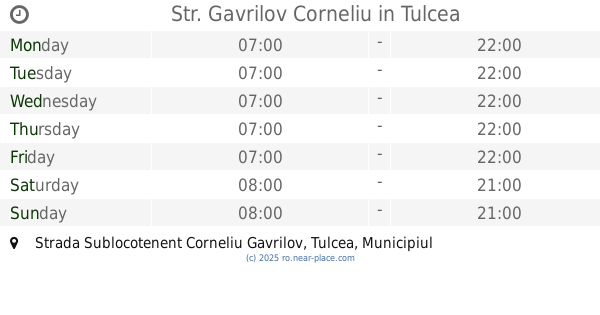
Str. Gavrilov Corneliu
Strada Sublocotenent Corneliu Gavrilov, Tulcea
Bus station
read more
966 m
Penny Market Vest
Strada 1848, Tulcea
Bus station
read more
1.007 km
Zarea
Strada Babadag, Tulcea
Bus station
read more
1.055 km
P-ta Marasesti
Strada Victoriei, Tulcea
Bus station
read more
1.111 km
Str. Isaceei
Strada Isaccei, Tulcea
Bus station
read more
1.114 km
Trandafirilor
Strada Bucovinei, Tulcea
Bus station
read more
1.182 km
Anghel Saligny
Strada Eternității, Tulcea
Bus station
read more
1.217 km
Parcul Personalităților
Tulcea
Bus station
read more
1.225 km
Independentei
Strada Isaccei, Tulcea
Bus station
read more
1.24 km
Ciuperca
Strada Isaccei, Tulcea
Bus station
read more
1.308 km
Stația Neptun
Strada Ion Luca Caragiale, Tulcea
Bus station
read more
1.334 km
Oficiul Postal Nr. 1
Strada Babadag, Tulcea
Bus station
read more
1.347 km
Gara CFR
Strada Portului, Tulcea
Bus station
read more
1.353 km
Autogara Tulcea
Strada Portului 26, Tulcea
Bus station
read more
1.374 km
Tulcea, Tulcea (Autogara Conex Trans)
Romania
Bus station
read more
1.451 km
Carol al-I-lea
Strada Isaccei, Tulcea
Bus station
read more
1.585 km
Eroilor
Strada Păcii, Tulcea
Bus station
read more
1.617 km
Geniului
Strada Eternității, Tulcea
Bus station
read more
1.661 km
Centru
Strada Babadag, Tulcea
Bus station
read more
1.676 km
Primaria Tulcea
Strada Păcii, Tulcea
Bus station
read more
1.695 km
Elizeu
Strada Păcii, Tulcea
Bus station
read more
1.755 km
Cocorului
Strada Eternității, Tulcea
Bus station
read more
📑
all categories
Accounting
Administrative area level 1
Administrative area level 2
Airport
Amusement park
Aquarium
Art gallery
Atm
Bakery
Bank
Bar
Beauty salon
Bicycle store
Book store
Bowling alley
Bus station
Cafe
Campground
Car dealer
Car rental
Car repair
Car wash
Casino
Cemetery
Church
City hall
Clothing store
Colloquial area
Convenience store
Country
Courthouse
Dentist
Department store
Doctor
Electrician
Electronics store
Embassy
Finance
Fire station
Florist
Food
Funeral home
Furniture store
Gas station
General contractor
Grocery or supermarket
Gym
Hair care
Hardware store
Health
Home goods store
Hospital
Insurance agency
Jewelry store
Laundry
Lawyer
Library
Light rail station
Liquor store
Local government office
Locality
Locksmith
Lodging
Meal delivery
Meal takeaway
Mosque
Movie rental
Movie theater
Moving company
Museum
Natural feature
Neighborhood
Night club
Painter
Park
Parking
Pet store
Pharmacy
Physiotherapist
Place of worship
Plumber
Point of interest
Police
Political
Post office
Premise
Real estate agency
Restaurant
Roofing contractor
Route
Rv park, camping
School
Shoe store
Shopping mall
Spa
Stadium
Storage
Store
Subpremise
Subway station
Supermarket
Synagogue
Taxi stand
Train station
Transit station
Travel agency
University
Veterinary care
Zoo
administrative area level 3
sublocality level 1
sublocality level 2
↑