Bar nearby Zoli Papadam
Romania
Bar nearby Zoli Papadam
Zoli Papadam
Strada Coziei 1, Oradea Rumania
contacts phone
:
+40
Latitude:
47.0491987
, Longitude:
21.9254867
read more
nearest Bar
614 m
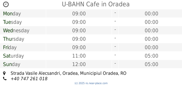
U-BAHN Cafe
nr 1, Strada Vasile Alecsandri, Oradea
Bar
read more
638 m
Bavaria Pub
Strada Mihail Kogălniceanu 3, Oradea
Bar
read more
638 m
Bavaria Restaurant&Pub
Strada Mihail Kogălniceanu 3, Oradea
Bar
read more
656 m
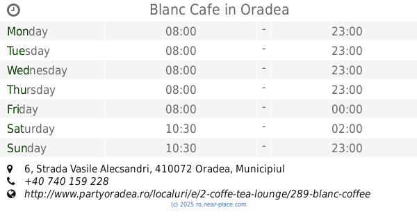
Blanc Cafe
Strada Vasile Alecsandri 6, Oradea
Bar
read more
678 m
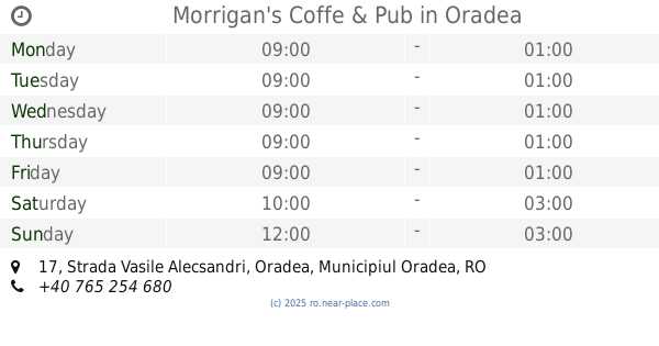
Morrigan's Coffe & Pub
Strada Vasile Alecsandri 17, Oradea
Bar
read more
679 m
Edison Pub
Piața Unirii 4, Oradea
Bar
read more
681 m
Morrigan's Coffe & Pub
Strada Vasile Alecsandri 19, Oradea
Bar
read more
684 m
Shot'n'go
Pasajul Vulturul Negru, Oradea
Bar
read more
687 m
Lord's
Pta Unirii, 2-4, Oradea, Bihor, 410072, Pasajul Vulturul Negru, Oradea
Bar
read more
688 m
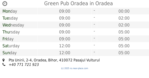
Green Pub Oradea
Pta Unirii, 2-4, Oradea, Bihor, 410072 Pasajul Vulturul Negru Oradea, Oradea
Bar
read more
708 m
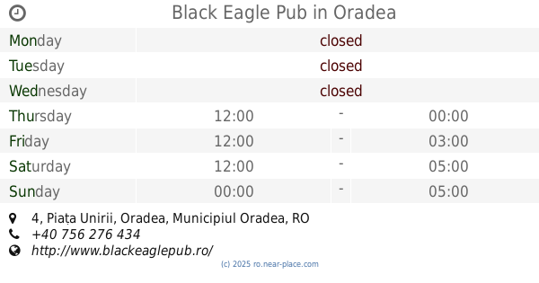
Black Eagle Pub
Piața Unirii 4, Oradea
Bar
read more
718 m
Coffe 2 Go Cretu
Strada Vasile Alecsandri 25, Oradea
Bar
read more
803 m
Bodega
Strada Arany János 7, Oradea
Bar
read more
877 m
Light Art Studio
Strada Grigore Ureche 8, Oradea
Bar
read more
931 m
Tapta Caffe
Strada Iosif Vulcan 9, Oradea
Bar
read more
985 m
Stefy Cafe
Strada Republicii 3, Oradea
Bar
read more
991 m
Restaurant Retro Oradea, Piata 22 Decembrie nr. 9 bl. R-10, jud. Bihor
R-10, Piața 22 Decembrie 9, Oradea
Bar
read more
996 m
TomPepe Lounge
Strada Gheorghe Costaforu 4, Oradea
Bar
read more
1.066 km
Gekko
Strada Tudor Vladimirescu 40, Oradea
Bar
read more
1.079 km
Lokal
Strada Aurel Lazăr 1, Oradea
Bar
read more
1.087 km
Moszkva Café
Strada Moscovei, Oradea
Bar
read more
1.195 km
RA
Parc. Traian, 1, Oradea, Bihor, 410033, Oradea
Bar
read more
1.339 km
Urban Place
Strada Tudor Vladimirescu 75, Oradea
Bar
read more
2.232 km
5 X 5 Sport Bar
Cartierul Ioşia Nord, Oradea
Bar
read more
2.627 km
Bancobet
Románia, Strada Constantin I Nottara 4, Oradea
Bar
read more
📑
all categories
Accounting
Administrative area level 1
Administrative area level 2
Airport
Amusement park
Aquarium
Art gallery
Atm
Bakery
Bank
Bar
Beauty salon
Bicycle store
Book store
Bowling alley
Bus station
Cafe
Campground
Car dealer
Car rental
Car repair
Car wash
Casino
Cemetery
Church
City hall
Clothing store
Colloquial area
Convenience store
Country
Courthouse
Dentist
Department store
Doctor
Electrician
Electronics store
Embassy
Finance
Fire station
Florist
Food
Funeral home
Furniture store
Gas station
General contractor
Grocery or supermarket
Gym
Hair care
Hardware store
Health
Home goods store
Hospital
Insurance agency
Jewelry store
Laundry
Lawyer
Library
Light rail station
Liquor store
Local government office
Locality
Locksmith
Lodging
Meal delivery
Meal takeaway
Mosque
Movie rental
Movie theater
Moving company
Museum
Natural feature
Neighborhood
Night club
Painter
Park
Parking
Pet store
Pharmacy
Physiotherapist
Place of worship
Plumber
Point of interest
Police
Political
Post office
Premise
Real estate agency
Restaurant
Roofing contractor
Route
Rv park, camping
School
Shoe store
Shopping mall
Spa
Stadium
Storage
Store
Subpremise
Subway station
Supermarket
Synagogue
Taxi stand
Train station
Transit station
Travel agency
University
Veterinary care
Zoo
administrative area level 3
sublocality level 1
sublocality level 2
↑