Bar nearby Big Coyote - BAR
Romania
Bar nearby Big Coyote - BAR
Big Coyote - BAR
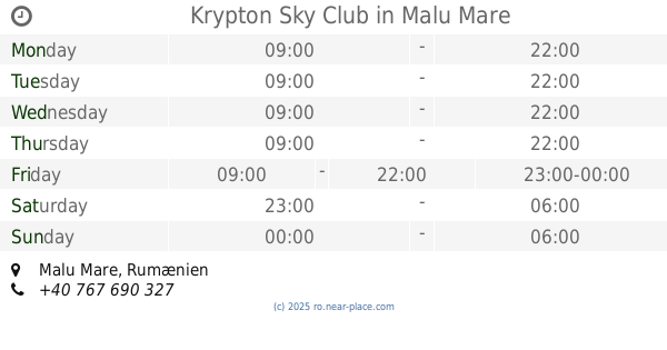
Strada Sergent Major Dorobanțu Constantin, Slatina România
contacts phone
:
+40
Latitude:
44.427077
, Longitude:
24.3642449
read more
nearest Bar
195 m
History
Strada Vintilă Vodă, Slatina
Bar
read more
243 m
Downtown
Aleea Independenței 2, Slatina
Bar
read more
391 m
Heaven on Seven
Strada Independenţei 3, Slatina
Bar
read more
413 m
Fiore Bianco
Aleea Independenței 1, Slatina
Bar
read more
462 m
Baroc Cafe Pub
Strada Sevastopol, Slatina
Bar
read more
550 m
Old Hound Pub
Strada Crișan Nr. 1, Slatina
Bar
read more
597 m
Fan Star
Bulevardul Nicolae Titulescu 33, Slatina
Bar
read more
771 m
Genos Caffe Bar
Strada Crișan 2, Slatina
Bar
read more
1.037 km
Memphis
Strada Drăgănești, Slatina
Bar
read more
1.272 km
Bar Esenta
Strada Mănăstirii, Slatina
Bar
read more
7.688 km
La ILIE la Garaj
Arceşti-Cot
Bar
read more
43.063 km
Krypton Sky Club
Malu Mare
Bar
read more
44.884 km
Scottish Pub
Strada Nicolae Julea 6, Craiova
Bar
read more
45.375 km
Wave 84
Strada Horia 16, Craiova
Bar
read more
45.793 km
Școala de Biliard
Strada General Magheru 1B, Craiova
Bar
read more
45.915 km
La Chitarre
Strada Anul 1848 67, Craiova
Bar
read more
45.976 km
Pensiunea Restaurant Carmelita
Strada Împăratul Traian 41, jud. Dolj, Craiova
Bar
read more
46.17 km
Boh Bou Bar
Unnamed Road, Craiova
Bar
read more
46.17 km
Il Forno Pub&Grill
Unnamed Road, Craiova
Bar
read more
46.269 km
Las Vegas
Str. Carol I, bloc M6B, parter, Craiova, judetul Dolj, Craiova
Bar
read more
46.596 km
Casa Berii Craiova
Strada Frații Buzești 22, Craiova
Bar
read more
48.117 km
Nădlag - Huelva
Strada Morii, Craiova
Bar
read more
50.557 km
Pensiune Restaurant Central Podari
Strada Dunării 100, Podari
Bar
read more
62.085 km
Cafe des Amis
Aleea Școlii Noi 12, Pitești
Bar
read more
64.676 km
Spalatorie Auto.
Strada Fitotron 35, Valea Mare-Podgoria
Bar
read more
📑
all categories
Accounting
Administrative area level 1
Administrative area level 2
Airport
Amusement park
Aquarium
Art gallery
Atm
Bakery
Bank
Bar
Beauty salon
Bicycle store
Book store
Bowling alley
Bus station
Cafe
Campground
Car dealer
Car rental
Car repair
Car wash
Casino
Cemetery
Church
City hall
Clothing store
Colloquial area
Convenience store
Country
Courthouse
Dentist
Department store
Doctor
Electrician
Electronics store
Embassy
Finance
Fire station
Florist
Food
Funeral home
Furniture store
Gas station
General contractor
Grocery or supermarket
Gym
Hair care
Hardware store
Health
Home goods store
Hospital
Insurance agency
Jewelry store
Laundry
Lawyer
Library
Light rail station
Liquor store
Local government office
Locality
Locksmith
Lodging
Meal delivery
Meal takeaway
Mosque
Movie rental
Movie theater
Moving company
Museum
Natural feature
Neighborhood
Night club
Painter
Park
Parking
Pet store
Pharmacy
Physiotherapist
Place of worship
Plumber
Point of interest
Police
Political
Post office
Premise
Real estate agency
Restaurant
Roofing contractor
Route
Rv park, camping
School
Shoe store
Shopping mall
Spa
Stadium
Storage
Store
Subpremise
Subway station
Supermarket
Synagogue
Taxi stand
Train station
Transit station
Travel agency
University
Veterinary care
Zoo
administrative area level 3
sublocality level 1
sublocality level 2
↑