Bar nearby Bar Old School
Romania
Bar nearby Bar Old School
Bar Old School
Strada Știrbei Vodă 123, București Rumänien
contacts phone
:
+40
Latitude:
44.4366914
, Longitude:
26.0793403
read more
nearest Bar
54 m
Silver Church
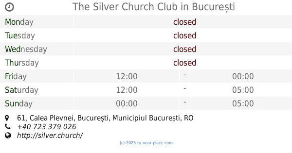
Calea Plevnei 61, București
Bar
read more
54 m
The Silver Church Club
Calea Plevnei 61, București
Bar
read more
343 m
Stuf Vama Veche
Strada Berzei 25A, București
Bar
read more
449 m
Ota
Strada Doctor Niculae D. Staicovici 26, București
Bar
read more
518 m
Dreamers Pub Caffee
Strada General H. M. Berthelot 111, București
Bar
read more
523 m
Cafe 35
Bulevardul Eroii Sanitari 35, București
Bar
read more
760 m
Bistro Nouveau
Strada Doctor Louis Pasteur 63, București
Bar
read more
764 m
Jazz Book Bistro
Strada Doctor Carol Davila 1, București
Bar
read more
781 m
Acolo
Calea Plevnei 8, București
Bar
read more
796 m
Living Club Bar
Calea Plevnei 6, București
Bar
read more
872 m
Bar Biblioteca
Strada Neajlovului 38, București
Bar
read more
1.033 km
J’ai Bistrot București
Calea Griviței 55, București
Bar
read more
1.033 km
Catre Parc Cismigiu
Strada Şipotul Fântânilor 9, București
Bar
read more
1.056 km
Rocca by The Jar
nr., Strada Theodor Aman Pictor 36, București
Bar
read more
1.067 km
Proseccobar
Strada Semicercului 4, București
Bar
read more
1.072 km
SPUMANTERIA
4, Semicercului nr, Strada Semicercului 4, București
Bar
read more
1.238 km
Gradina EDEN
Calea Victoriei 107, București
Bar
read more
1.715 km
Pura Vida Sky
Strada Smârdan 7, București
Bar
read more
1.78 km
InBox Bar
Bulevardul Lascăr Catargiu 6, București
Bar
read more
1.794 km
55 Jazz
Strada Franceză 13, București
Bar
read more
1.808 km
Bound
Strada Smârdan 30, București
Bar
read more
1.918 km
Niște Domni și Fiii
Strada Covaci 11, București
Bar
read more
1.924 km
CIRCUIT
Strada Căderea Bastiliei 19, București
Bar
read more
1.978 km
Happy Pub
Strada Căderea Bastiliei 36, București
Bar
read more
2.042 km
POINT
Strada General Eremia Grigorescu 10, București
Bar
read more
📑
all categories
Accounting
Administrative area level 1
Administrative area level 2
Airport
Amusement park
Aquarium
Art gallery
Atm
Bakery
Bank
Bar
Beauty salon
Bicycle store
Book store
Bowling alley
Bus station
Cafe
Campground
Car dealer
Car rental
Car repair
Car wash
Casino
Cemetery
Church
City hall
Clothing store
Colloquial area
Convenience store
Country
Courthouse
Dentist
Department store
Doctor
Electrician
Electronics store
Embassy
Finance
Fire station
Florist
Food
Funeral home
Furniture store
Gas station
General contractor
Grocery or supermarket
Gym
Hair care
Hardware store
Health
Home goods store
Hospital
Insurance agency
Jewelry store
Laundry
Lawyer
Library
Light rail station
Liquor store
Local government office
Locality
Locksmith
Lodging
Meal delivery
Meal takeaway
Mosque
Movie rental
Movie theater
Moving company
Museum
Natural feature
Neighborhood
Night club
Painter
Park
Parking
Pet store
Pharmacy
Physiotherapist
Place of worship
Plumber
Point of interest
Police
Political
Post office
Premise
Real estate agency
Restaurant
Roofing contractor
Route
Rv park, camping
School
Shoe store
Shopping mall
Spa
Stadium
Storage
Store
Subpremise
Subway station
Supermarket
Synagogue
Taxi stand
Train station
Transit station
Travel agency
University
Veterinary care
Zoo
administrative area level 3
sublocality level 1
sublocality level 2
↑