Restaurant nearby Restaurant Aida
Romania
Restaurant nearby Restaurant Aida
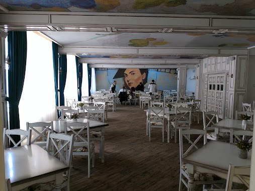
Restaurant Aida
Strada Moldova 13, Focșani Rumania
contacts phone
:
+40
Latitude:
45.6996674
, Longitude:
27.1936541
read more
nearest Restaurant
14 m
Romantic
Strada Moldova 8, Focșani
Restaurant
read more
104 m
Restaurant Oscar
Comisia Centrala, Focșani
Restaurant
read more
431 m
Nadria
Strada Cuza Vodă, Focșani
Restaurant
read more
431 m
NADRIA Wi-Fi Intrenet Free
Strada Cuza Vodă, Focșani
Restaurant
read more
437 m
Casa Vrânceană
Strada Simion Bărnuţiu 7-9, Focșani
Restaurant
read more
469 m
Restaurant ENIGMA
Strada Măgura 68, Focșani
Restaurant
read more
521 m
CIULEANDRA
Strada Simion Bărnuţiu, Focșani
Restaurant
read more
546 m
Pacific
Strada Ana Ipătescu 19, Focșani
Restaurant
read more
653 m
Restaurant Zimbru
republicii, Focșani
Restaurant
read more
660 m
Dabo Doner Focsani
Strada Mihail Kogălniceanu 10-21, Focșani
Restaurant
read more
732 m
Ray Com Mode S.R.L.
Calea Moldovei 1, Focșani
Restaurant
read more
738 m
Zanfir Bistro
Strada Republicii 64, Focșani
Restaurant
read more
760 m
Pizzeria WOW
Strada Lupeni 58, Focșani
Restaurant
read more
789 m
Bistro RAL - Local Autentic Romanesc
Strada Piața Moldovei, Focșani
Restaurant
read more
844 m
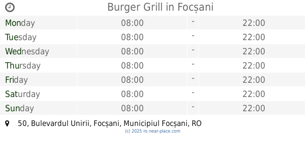
Burger Grill
Bulevardul Unirii 50, Focșani
Restaurant
read more
854 m
Restaurant Palace
Bulevardul Unirii 1-3, Focșani
Restaurant
read more
869 m
Central Restaurant
Bulevardul Unirii 61, Focșani
Restaurant
read more
883 m
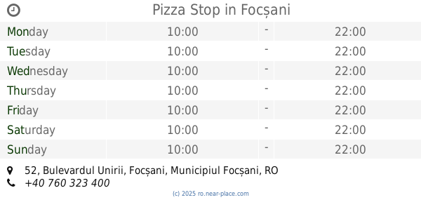
Pizza Stop
Bulevardul Unirii 52, Focșani
Restaurant
read more
890 m
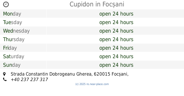
Cupidon
Strada Constantin Dobrogeanu Gherea, Focșani
Restaurant
read more
940 m
Casa Veche
Strada Renașterii 10, Focșani
Restaurant
read more
964 m
Metex
Strada Republicii 16, Focșani
Restaurant
read more
1.018 km
LumyRob
Strada Plantelor 23, Focșani
Restaurant
read more
1.019 km
Restaurant Lumirob
Bloc 4, Bulevardul Dimitrie Cantemir 3, București
Restaurant
read more
1.08 km
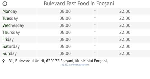
Bulevard Fast Food
Bulevardul Unirii 31, Focșani
Restaurant
read more
1.08 km
Ilpiacere
Focșani
Restaurant
read more
📑
all categories
Accounting
Administrative area level 1
Administrative area level 2
Airport
Amusement park
Aquarium
Art gallery
Atm
Bakery
Bank
Bar
Beauty salon
Bicycle store
Book store
Bowling alley
Bus station
Cafe
Campground
Car dealer
Car rental
Car repair
Car wash
Casino
Cemetery
Church
City hall
Clothing store
Colloquial area
Convenience store
Country
Courthouse
Dentist
Department store
Doctor
Electrician
Electronics store
Embassy
Finance
Fire station
Florist
Food
Funeral home
Furniture store
Gas station
General contractor
Grocery or supermarket
Gym
Hair care
Hardware store
Health
Home goods store
Hospital
Insurance agency
Jewelry store
Laundry
Lawyer
Library
Light rail station
Liquor store
Local government office
Locality
Locksmith
Lodging
Meal delivery
Meal takeaway
Mosque
Movie rental
Movie theater
Moving company
Museum
Natural feature
Neighborhood
Night club
Painter
Park
Parking
Pet store
Pharmacy
Physiotherapist
Place of worship
Plumber
Point of interest
Police
Political
Post office
Premise
Real estate agency
Restaurant
Roofing contractor
Route
Rv park, camping
School
Shoe store
Shopping mall
Spa
Stadium
Storage
Store
Subpremise
Subway station
Supermarket
Synagogue
Taxi stand
Train station
Transit station
Travel agency
University
Veterinary care
Zoo
administrative area level 3
sublocality level 1
sublocality level 2
↑