Park nearby Piata Regele Ferdinand I
Coronavirus disease (COVID-19) Situation
confirmed cases
3529735
deaths
68929
Romania
Park nearby Piata Regele Ferdinand I
Piata Regele Ferdinand I
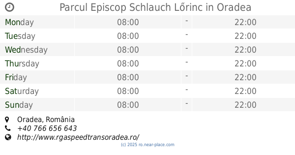
Oradea, România
contacts phone
:
+40
Latitude:
47.0568449
, Longitude:
21.9303673
larger map & directions
read more
nearest Park
382 m
Parcul Traian
Oradea
Park
read more
387 m
Parcul Libertatii
Podul Intelectualilor, Oradea
Park
read more
471 m
Regia Națională a Pădurilor - ROMSILVA, Direcția Silvică Bihor
Strada Mihai Eminescu 15, Oradea
Park
read more
746 m
Piața Emanuil Gojdu
Aleea Emanuil Gojdu, Oradea
Park
read more
822 m
Parc
Oradea
Park
read more
888 m
Park Nicolae Bălcescu
Strada Sucevei 79, Oradea
Park
read more
888 m
Parcul "Nicolae Bălcescu"
Strada Sucevei 79, Oradea
Park
read more
1.148 km
Bunyitay liget
Olosig, Oradea
Park
read more
1.19 km
Parc dendrologic
Oradea
Park
read more
1.242 km
Parcul Episcop Schlauch Lőrinc
Oradea
Park
read more
1.367 km
Parcul Negruzzi
Strada Sfântul Apostol Andrei 83, Oradea
Park
read more
1.368 km
Parc
Decebal - Dacia, Oradea
Park
read more
1.37 km
Parc Doina
Strada Sfântul Apostol Andrei 83, Oradea
Park
read more
1.443 km
La Fantani
Strada Păcii 13, Oradea
Park
read more
1.496 km
Parcul Piața 22 Decembrie
Oradea
Park
read more
1.496 km
22nd December Park
Parcul Piața 22 Decembrie, Piața 22 Decembrie, Oradea
Park
read more
1.496 km
Parcul 22 Decembrie
Parcul Piața 22 Decembrie, Piața 22 Decembrie, Oradea
Park
read more
1.511 km
Szent Margit tér
Dorobanților, Oradea
Park
read more
1.556 km
Dealul Ciuperca
Strada Graurilor 23, Oradea
Park
read more
1.623 km
Parc Splai
Oradea
Park
read more
1.828 km
Parcul Padiș
Oradea
Park
read more
1.887 km
Parcul Taranilor
Dimitrie Cantemir, Oradea
Park
read more
1.897 km
Piața Țăranilor
Oradea
Park
read more
2.025 km
Parc Iosia
Oradea
Park
read more
2.156 km
Park
Decebal - Dacia, Oradea
Park
read more
📑
all categories
Accounting
Administrative area level 1
Administrative area level 2
Airport
Amusement park
Aquarium
Art gallery
Atm
Bakery
Bank
Bar
Beauty salon
Bicycle store
Book store
Bowling alley
Bus station
Cafe
Campground
Car dealer
Car rental
Car repair
Car wash
Casino
Cemetery
Church
City hall
Clothing store
Colloquial area
Convenience store
Country
Courthouse
Dentist
Department store
Doctor
Electrician
Electronics store
Embassy
Finance
Fire station
Florist
Food
Funeral home
Furniture store
Gas station
General contractor
Grocery or supermarket
Gym
Hair care
Hardware store
Health
Home goods store
Hospital
Insurance agency
Jewelry store
Laundry
Lawyer
Library
Light rail station
Liquor store
Local government office
Locality
Locksmith
Lodging
Meal delivery
Meal takeaway
Mosque
Movie rental
Movie theater
Moving company
Museum
Natural feature
Neighborhood
Night club
Painter
Park
Parking
Pet store
Pharmacy
Physiotherapist
Place of worship
Plumber
Point of interest
Police
Political
Post office
Premise
Real estate agency
Restaurant
Roofing contractor
Route
Rv park, camping
School
Shoe store
Shopping mall
Spa
Stadium
Storage
Store
Subpremise
Subway station
Supermarket
Synagogue
Taxi stand
Train station
Transit station
Travel agency
University
Veterinary care
Zoo
administrative area level 3
sublocality level 1
sublocality level 2
↑