Park nearby Parcul Otopeni
Coronavirus disease (COVID-19) Situation
confirmed cases
3529735
deaths
68929
Romania
Park nearby Parcul Otopeni
Parcul Otopeni
Otopeni 075100, Romania
contacts phone
:
+40
Latitude:
44.5505102
, Longitude:
26.0728044
larger map & directions
read more
nearest Park
566 m
foraje puturi
Otopeni
Park
read more
1.521 km
JoacaCuMinte
Str. Drumul Garii nr. 4, Otopeni
Park
read more
2.332 km
MADEX INTERNAŢIONAL S.R.L.
Șoseaua Odăii 117-123, București
Park
read more
2.599 km
Parcul Platanilor
Greenfield, București
Park
read more
4.754 km
Padurea Petresti
Park
read more
5.354 km
Memorial to the Victims of Balotesti
Balotești
Park
read more
5.354 km
Memorialul Victimelor de la Balotesti
Balotești
Park
read more
5.392 km
Robinia Village
Tamași
Park
read more
7.519 km
Bazilescu Park
Bucureștii Noi, Bucharest
Park
read more
8.108 km
Parc
Strada Holdelor, Chitila
Park
read more
8.963 km
King Michael I Park
Bucharest
Park
read more
8.963 km
Parcul Regele Mihai I al României (Parcul Herăstrău)
București
Park
read more
9.037 km
Câmp didactic experimental (Livada II)
Bucharest
Park
read more
9.361 km
Parcul Verdi
Bukareszt
Park
read more
10.046 km
King David square
Ștefăneștii de Jos
Park
read more
10.36 km
Kiseleff Park
Bucharest
Park
read more
11.73 km
Park Ion Creanga
Strada Nicolae Apostol 102, București
Park
read more
12.595 km
Titus Ozon
Strada Căminului 28, București
Park
read more
13.173 km
Parc
Strada Ghirlandei 1, București
Park
read more
13.52 km
Parcul Ostrov
Sector 2
Park
read more
13.693 km
Parcul Delfinului
Aleea Dobrina, București
Park
read more
14.068 km
Parcul Bibescu
Sector 4
Park
read more
14.102 km
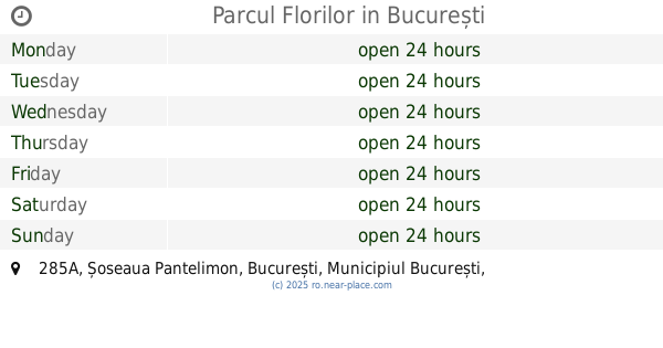
Parcul Florilor
Șoseaua Pantelimon 285A, București
Park
read more
15.309 km
Rosarium
Strada Câmpia Libertății, București
Park
read more
16.712 km
Parcul Codrii Neamţului
Sector 3
Park
read more
📑
all categories
Accounting
Administrative area level 1
Administrative area level 2
Airport
Amusement park
Aquarium
Art gallery
Atm
Bakery
Bank
Bar
Beauty salon
Bicycle store
Book store
Bowling alley
Bus station
Cafe
Campground
Car dealer
Car rental
Car repair
Car wash
Casino
Cemetery
Church
City hall
Clothing store
Colloquial area
Convenience store
Country
Courthouse
Dentist
Department store
Doctor
Electrician
Electronics store
Embassy
Finance
Fire station
Florist
Food
Funeral home
Furniture store
Gas station
General contractor
Grocery or supermarket
Gym
Hair care
Hardware store
Health
Home goods store
Hospital
Insurance agency
Jewelry store
Laundry
Lawyer
Library
Light rail station
Liquor store
Local government office
Locality
Locksmith
Lodging
Meal delivery
Meal takeaway
Mosque
Movie rental
Movie theater
Moving company
Museum
Natural feature
Neighborhood
Night club
Painter
Park
Parking
Pet store
Pharmacy
Physiotherapist
Place of worship
Plumber
Point of interest
Police
Political
Post office
Premise
Real estate agency
Restaurant
Roofing contractor
Route
Rv park, camping
School
Shoe store
Shopping mall
Spa
Stadium
Storage
Store
Subpremise
Subway station
Supermarket
Synagogue
Taxi stand
Train station
Transit station
Travel agency
University
Veterinary care
Zoo
administrative area level 3
sublocality level 1
sublocality level 2
↑