Bar nearby AYAN Bar&Games
Romania
Bar nearby AYAN Bar&Games
AYAN Bar&Games
Unnamed Road, Râmnicu Vâlcea Rumania
contacts phone
:
+40
Latitude:
45.103623
, Longitude:
24.363974
read more
nearest Bar
76 m
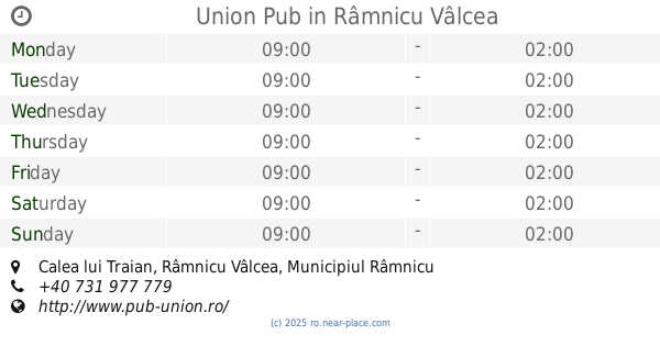
Union Pub
Calea lui Traian, Râmnicu Vâlcea
Bar
read more
293 m
Jazz Bar Pour Les Connaisseurs
Centru, Râmnicu Vâlcea
Bar
read more
667 m
Club Winners'
Strada Dacia 17, Râmnicu Vâlcea
Bar
read more
866 m
BAR DOI COCOSI
Strada George Coșbuc 11,Râmnicu Vâlcea, Râmnicu Vâlcea
Bar
read more
947 m
Bar FERY
Strada Petrişor 13, 1, Râmnicu Vâlcea
Bar
read more
1.444 km
Creator Bar Terasa
Strada Lucian Blaga, Râmnicu Vâlcea
Bar
read more
1.455 km
La Pișpirică la W
Unnamed Road, Râmnicu Vâlcea
Bar
read more
1.468 km
Bar Marlene
Ostroveni, Râmnicu Vâlcea
Bar
read more
1.553 km
KTY SPORT PUB
Strada Rapsodiei 19, Râmnicu Vâlcea
Bar
read more
1.681 km
Naturo Juice
Râmnicu Vâlcea
Bar
read more
1.916 km
Brothers Pub
Bulevardul Dem Radulescu, Râmnicu Vâlcea
Bar
read more
2.934 km
Centrul de Expoziții și Evenimente Sofianu
str. Posada nr. 1, Râmnicu Vâlcea
Bar
read more
4.737 km
MiniMarchet
Budești
Bar
read more
7.773 km
La Codita
Bârsești
Bar
read more
8.092 km
Piscina Dăești
Sânbotin
Bar
read more
41.812 km
Plaja publica Budeasa
Budeasa Mare
Bar
read more
47.801 km
BEST ELYMAR 2006
5, Bulevardul Libertății, Pitești
Bar
read more
48.031 km
Urban Home
Strada Victoriei 17, Pitești
Bar
read more
48.089 km
Guinness Pub Lounge
Str. Victoriei 30, Pitești
Bar
read more
48.115 km
Hanul Rosu
Strada Pieței Vis A Vis De Parcarea Supraterana, Mioveni
Bar
read more
49.049 km
Class Lounge
Strada Vasile Lupu 2, Pitești
Bar
read more
49.103 km
Superbet
Strada Exercițiu, Pitești
Bar
read more
50.52 km
Cafe des Amis
Aleea Școlii Noi 12, Pitești
Bar
read more
50.555 km
Spalatorie Auto.
Strada Fitotron 35, Valea Mare-Podgoria
Bar
read more
56.886 km
Tolosan Automotivs
Văleni-Podgoria
Bar
read more
📑
all categories
Accounting
Administrative area level 1
Administrative area level 2
Airport
Amusement park
Aquarium
Art gallery
Atm
Bakery
Bank
Bar
Beauty salon
Bicycle store
Book store
Bowling alley
Bus station
Cafe
Campground
Car dealer
Car rental
Car repair
Car wash
Casino
Cemetery
Church
City hall
Clothing store
Colloquial area
Convenience store
Country
Courthouse
Dentist
Department store
Doctor
Electrician
Electronics store
Embassy
Finance
Fire station
Florist
Food
Funeral home
Furniture store
Gas station
General contractor
Grocery or supermarket
Gym
Hair care
Hardware store
Health
Home goods store
Hospital
Insurance agency
Jewelry store
Laundry
Lawyer
Library
Light rail station
Liquor store
Local government office
Locality
Locksmith
Lodging
Meal delivery
Meal takeaway
Mosque
Movie rental
Movie theater
Moving company
Museum
Natural feature
Neighborhood
Night club
Painter
Park
Parking
Pet store
Pharmacy
Physiotherapist
Place of worship
Plumber
Point of interest
Police
Political
Post office
Premise
Real estate agency
Restaurant
Roofing contractor
Route
Rv park, camping
School
Shoe store
Shopping mall
Spa
Stadium
Storage
Store
Subpremise
Subway station
Supermarket
Synagogue
Taxi stand
Train station
Transit station
Travel agency
University
Veterinary care
Zoo
administrative area level 3
sublocality level 1
sublocality level 2
↑